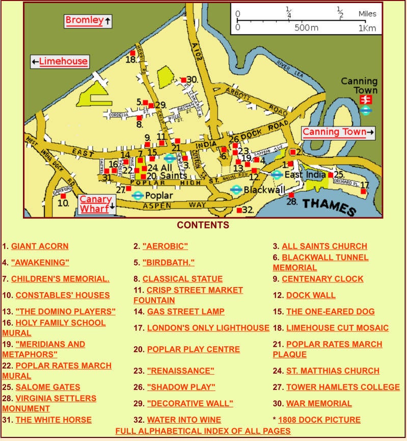
Two alternative Eastward routes:
1a: POPLAR to BLACKWALL DLR, then on to DATA CENTERS CAMPUS (EAST INDIA DOCKS, site of IMPORT DOCK) and LOWER LEA VIADUCT
1b: POPLAR to BLACKWALL DLR, crossing ASPEN WAY subway to POPLAR DOCK WEST INDIA DOCKS), and then on to BLACKWALL riverside (site of EXPORT DOCK, of the EAST INDIA)

DUE EAST 1a: From POPLAR to BLACKWALL (from here diverts an alternative route) EAST INDIA DOCK BASIN TRINITY BUOY WHARF and CITY ISLAND and on to CANNING TOWN
In this chapter
- The 1951FESTIVAL OF BRITAIN in POPLAR
- GEORGE LANSBURY and the POPLAR RATES
- TRINITY HOUSE: LIGHT HOUSES & BUOYS. NOW, ARTS CENTRE
- FIRST AMERICAN COLONS
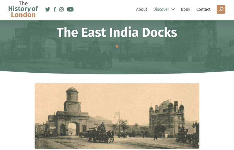
- EAST INDIA DOCKS


Exploring East London: a very useful web!!!
TWO MUSEUMS NEARBY containing info about LONDON DOCKLANDS

Call the Midwife”
POPLAR. You are still in TOWER HAMLETS
CHRISP STREET MARKET
2026. 75th Anniversary of the FESTIVAL OF BRITAIN
The area of Poplar was a key site for the Festival of Britain in 1951, specifically hosting the "Live Architecture Exhibition" on the new Lansbury Estate.
The Poplar site was chosen to showcase the best of post-war town planning and architecture, as much of the area had been heavily damaged during World War II. The "Live Architecture Exhibition" allowed visitors to tour a self-contained, under-construction neighbourhood, including new homes, schools, and shops.
Key aspects of the exhibition in Poplar:
- Location: The Lansbury Estate, an area selected to demonstrate urban reconstruction and modern living.
- Features: Included a furnished show flat, a Building Research Pavilion, a Town Planning Pavilion, and a mock-up of an imaginary town called "Avoncaster".
- Purpose: It was intended to be a practical example of the future of British housing and community planning, a "tonic for the nation" alongside the main South Bank exhibition.
East India Dock Road (the road build for the new Docks)
COMMERCIAL ROAD and EAST INDIA DOCKS ROAD: https://islandhistory.wordpress.com/2020/10/05/commercial-road/

Nearby
Former PUBLIC BATHS
RICHARD GREEN Statue
He entered the family firm it became Green, Wigram & Green. After his father's death he continued it with his younger half-brother Henry. Green had great business skill and was best known for his development of the last generation of East Indiamen called 'Blackwall frigates', built at Green's Blackwall yard on the Thames, and ships for the Australian trade, especially after the discovery of gold in Port Phillip (later Victoria) in 1852. To these shipowning successes he was beginning to add a China-trade dimension at the time of his death. Green was also a noted philanthropist, promoting children's education, improvement in merchant marine conditions and fostering the naval reserve. He established and endowed the Sailors' Home at Poplar and was benefactor to schools and other institutions in East London including the Merchant Seaman's Orphan Asylum, the Dreadnought Seaman's Hospital at Greenwich and the Poplar Hospital. He appears in the original 'Dictionary of National Biogr
https://artuk.org/discover/artworks/richard-green-18031863-313444
Former GEORGE GREEN SCHOOL. CENTENARY CLOCK
Green was the founder of the well known Blackwall shipbuilding and shipowning family of that name. Having been apprenticed to John Perry in his Blackwall yard at the age of 15 he married Perry's daughter in 1796, and became a partner in 1797. Perry became his brother- and well as father-in-law when he subsequently married Green's sister as his second wife.
After Perry's retirement in 1803 Green and subsequently his sons, of whom Richard was the oldest and leading partner, were in partnership with the Wigrams until 1843. The time-limited Wigram & Green partnership then expired and the Blackwall yard was divided between them. The Green company, which after George's death became 'R & H.Green', retained the eastern half. In 1902 it became part of the ship repairers, Green & Silley Weir. This was nationalized into the Government-owned Thames Shiprepairers Ltd in the 1970s, itself wound-up in the 1980s. George and Richard were both noted philanthropists

Woodstock Terrace
Conservation Area
POPLAR RECREATION GROUND CHILDREN’S MEMORIAL
Now a community centre, before ST.MATHIAS Church. Originally, POPLAR CHAPEL, of the the EAST INDIA COMPANY
Built in 1654 this is one of the very few extant churches built under the Commonwealth.
In 1627 the East India Company (EIC) purchased a house in Poplar High Street to be used as a hospital for disabled seamen. In 1618 a corrupt jeweller, Hugh Greete, had been sent back from India for stealing stones. He died in prison in 1619, and directed that a school or hospital be founded from his estate. The Company had set up a shipyard in Blackwall in 1614, so neighbouring Poplar was the obvious choice for location. In 1633 the inhabitants of Poplar and Blackwall – largely employees of the EIC – requested that a chapel be built there as St Dunstan's, Stepney was too far away for them.
Thanks to bequests and money direct from the Company, work got properly underway in 1652. The first payment was made to John Tanner, Master of the Bricklayers' Company in 1654, who became the principal builder.
The burial ground was allotted to the chapel in 1657.
a brick building enhanced with stone quoins at the corners. It combines Classical and Gothic elements, similar to St Katherine Cree in the City of London, consecrated in 1631.
Internally, the barrel-vaulted roof is supported by eight Tuscan columns, seven of oak and one of stone. There is no evidence to support the story that they were made from ships' masts. This gives a Dutch flavour to the architecture reminiscent of Hendrick de Keyser who built several churches in Amsterdam in the early seventeenth century.
a tower added (1718), a triple-decker pulpit (1733) and extensive repairs and alterations to the windows in 1775–1776 (architect: Richard Jupp). In the early 19th century a mural monument to George Steevensby John Flaxman was commissioned; this is currently on loan to the Fitzwilliam Museum, Cambridge.
For many years the Chapel was used for prayers before mariners and passengers departed on what might prove to be a dangerous voyage. Many early migrants to British North America would have participated in these services, before leaving for an uncertain future abroad. It was also the chapel of the adjacent almshouses, home to the Poplar Pensioners, seamen retired from the EIC.
the EIC was wound up and Poplar Chapel became St Matthias, a Church of England parish church.
in the 1970s St Matthias merged with St Anne's, Limehouse. In 1992 the St Matthias Conservation trust was set up to preserve the building and provide use as a community centre.
Poplar High Street
MERIDIAN HOUSE
built in 1801-2 by the East India Company, to house the chaplain serving the company's almshouses and chapel. the company earmarked diamond trader and crook Hugh Greete’s money to build an almshouse for disabled seamen, their widows and orphans (as directed by the very will of the crook)
The almshouse opened in 1628, and it was maintained by a levy on the wages of East India Company employees, known as the Poplar Fund.[6][7] This fund financed the building of Meridian House.
Meridian House was presumably designed by East India Company surveyor Henry Holland. It is made of stock brick and carries a pediment with the East India Company's arms.
Former POPLAR TOWN HALL
The building was commissioned by the Poplar District Board of Works to serve as its hall and offices.[2] The site the board selected, on the north side of Poplar High Street, had been occupied by a row of alms houses erected by the East India Company in 1628.
in the Gothic Revival style, built in yellow brick at a cost of £7,500 and was completed in October 1870.
The building became the headquarters of the Metropolitan Borough of Poplar in 1900.[5][6],[7][8] The building ceased to be the local seat of government when the council moved to the new town hall in Bow Street in 1938. The old town hall remained in council ownership, being used as a district housing centre from 1986, until Tower Hamlets London Borough Council sold it to a developer, Dreamstar Limited, in 2011. It was subsequently converted into a boutique hotel, opening as the Lansbury Heritage Hotel in 2015.
GEORGE LANSBURY
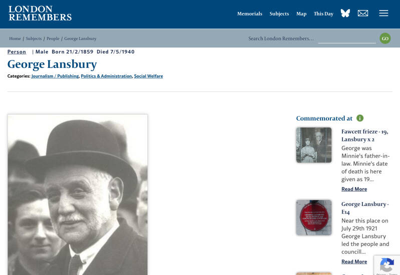
It was the scene of the Poplar Rates Rebellion, led by George Lansbury, which advocated the use of rates for social reform and ultimately resulted in 19 councillors being put in prison in 1921.
CORONERS COURT
Former Railway Building

Nearby
ALL SAINTS Church
The true foundations had been laid 425 years earlier, when in 1396, the small village of ‘Popelar’ with Blackwall had been granted to the Cistercian monks of the Abbey of St Mary de Graces just by the Tower of London, and came to be known as one of the Tower Hamlets in the parish of Stepney. The settlements provided some of the labour-force for the expanding City of London, including the militiamen at the Tower, as well as crops and livestock from the newly drained marshland. By the time the land was sold off to private families under Henry VIII, the Blackwall area had also established a thriving shipbuilding and repairing industry.
St Dunstan's, Stepney, was then the Parish Church, and baptismal records from the early 17th century show that just over half the fathers in Poplar were occupied in river or sea trades.
At the beginning of the 19th century, to escape the heavy duties levied on cargoes discharged within the City itself, massive capital expenditure was risked in the building of docks eastward of the Pool of London.
by 1811 the population of Blackwall and Poplar was over 7,000 and in the next 50 years it increased to 43,000.
A new wealthy class of merchants began to move into the area and in 1817 Parliament enacted a law which made Poplar a parish in its own right
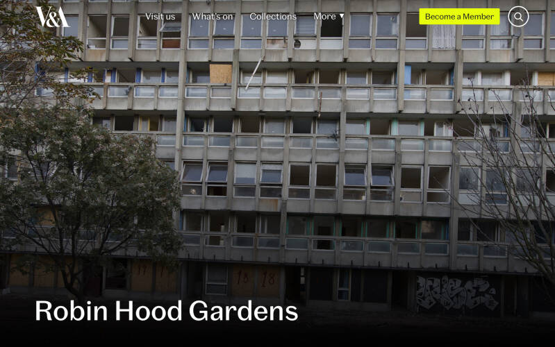
Former ROBIN HOOD GARDENS (Social Housing).
A residential estate designed in the late 1960s by architects Alison and Peter Smithson and completed in 1972. It was built as a council housing estate with homes spread across 'streets in the sky': social housing characterised by broad aerial walkways in long concrete blocks, much like the Park Hill estate in Sheffield; it was informed by, and a reaction against, Le Corbusier's Unité d'Habitation.
A redevelopment scheme, known as Blackwall Reach, involves the demolition of Robin Hood Gardens as part of a wider local regeneration project that was approved in 2012. An attempt supported by a number of notable architects to head off redevelopment by securing listed status for the estate was rejected by the government in 2009. Demolition of the western block began in December 2017 and was completed in 2018. Demolition of the Eastern block started in mid 2024 and finished in March 2025.
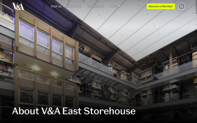
Part of the building has been preserved by the Victoria and Albert Museum[4] and was presented at the Venice Architecture Biennalein 2018.
Social housing in a museum… V&A EAST STOREHOUSE
BLACKWALL
BLACKWALL TUNNEL (North entrance)
Docks gate and Tunnel entrance: https://londontraveller.org/2013/05/17/east-india-docks/

Route to POPLAR DOCK (WEST INDIA DOCKS) and Blackwall Riverside: VIRGINIA QUAY & EAST INDIA BASIN


Naval Row
Naval House
Erected in 1928–9 by the Borough of Poplar, this block of flats at the east corner of Naval Row and Quixley Street stands on the site of one of the two sets of stables built in 1834 for letting to coach and omnibus operators. It was designed by the Borough Surveyor, Harley Heckford, and is in the simplified neo-Georgian style favoured by the Borough for its public housing in the 1920s. The builder was R. A. Reader of Hackney, whose tendered price was £8,997, and the total cost of the scheme, including the land (purchased from the PLA), was £10,802
Former THE STEAMSHIP P.H.
Former Pumping Station
Constructed in 1857, the Italianate-style building was designed by engineer Henry Martin to supply hydraulic power to the East India Docks.
It was extended in the late 1870s to accommodate machinery that operated the gates of a new entrance lock. The hydraulic equipment was eventually replaced with electrical machinery in 1925.
Enter the High Walls…
Eateries and convenience stores
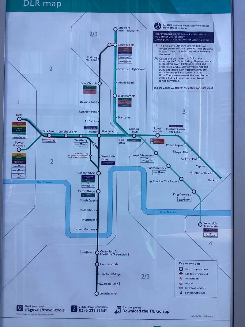
EAST INDIA DLR Station
Site of the EAST INDIA DOCKS

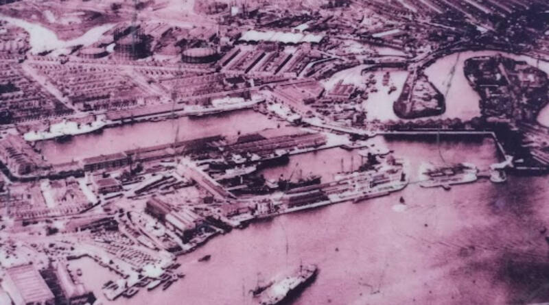
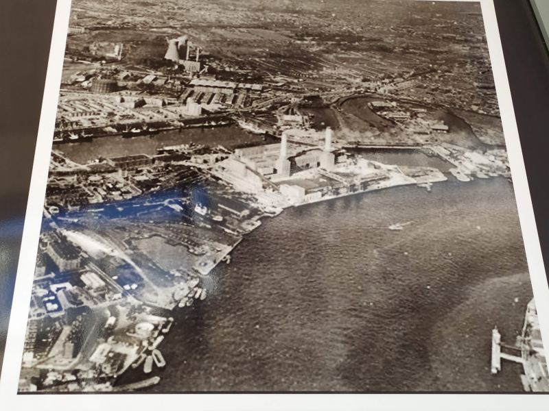
For 150 years the East India Docks were one of London’s main Thames dock complexes. They were originally created at the start of the 19th century for the loading and unloading of the East India Company ships trading with the Far East.
The East India Company was formed by London merchants at the very end of the 16th century to fund voyages to the Far East to source spices and other exotic goods. Their first sailing of a small fleet of ships departed from Woolwich in 1601. Between 1614 and 1619 they created their own ship-building yard
The yard at Blackwall was sold in 1653 to the shipwright Henry Johnson. A century later the yard was owned by John Perry and was then known as the Brunswick Dock, a popular name in the 18th century because the Georgian kings of Britain were also the Dukes of Brunswick in Germany.
The dock was also a base for whaling ships, with warehouses for the storing of whalebone and blubber. Blackwall was still an isolated and rural area and the dock was surrounded by POPLAR trees to act as a windbreak.
The silks and spices brought back from the Far East by the East India Company were very valuable so from the latter part of the 18th century the company developed a complex of secure warehouses at Cutler Street, just to the east of Bishopsgate. Their returning ships moored in the open river at Blackwall and ferried goods from there on smaller 100-ton barges.
One type of merchandise they imported was saltpetre, which is a main constituent of gunpowder. It is highly flammable so the company stored it away from the City at Shadwell in a warehouse that opened in 1775.
From the early 19th century tea was stored at a warehouse at Crutched Friar, at the top of Tower Hill. That building was eventually inherited by the Port of London Authority
The Thames became congested with ships during the 18th century and there was a great deal of theft while they waited to unload in the Pool of London. Therefore, at the end of the century, London’s shipowners decided to create off-river dock.
A new proposal to create a third set of docks came from a group of shipowners involved in the East India trade, led by Robert Wigram and John Woolmore, rather than the East India Company itself. An Act of Parliament to create the East India Docks was passed in July 1803,
The dock company purchased Brunswick Dock at Blackwall that had been sold by the East India Company in the 17th century, and additional land of the BROMLEY MARSH.
In the early 1830s the East India Company itself suffered a financial crisis. Their India monopoly had ended in 1813 and their China monopoly in 1833. With the financial crisis at the East India Company the dock company was deprived of its use of the warehouses in the City. With the opening of the St. Katharine Docks and new riverside wharves there was over-capacity for the berthing of ships on the Thames and the business became highly competitive. The East India Docks had been created with minimal warehousing from which to profit in the new, competitive open market in which it then found itself. On the other hand, the West India Docks had too much warehousing. It therefore made sense for the two companies to merge, which they did in 1838. Thereafter the two sets of docks no longer specialised in West India or East India trades but handled general merchandise, whatever its origin.
MULBERRY PLACE, former L.B. TOWER HAMLETS Town Hall
In the early 1990s, the council decided to move to a more modern building, on the site of the former East India Import Dock. The new Town Hall, completed in 1992 and occupied the following year, was built by the Nordic Construction Company, with Birse Construction the main contractor. The new building formed part of a larger development of four linked blocks, designed by Sten Samuelson and the Beaton Thomas Partnership in the Modernist style. The design made extensive use of reflective glazing and pink Sardinian granite.
The name Mulberry Place commemorates the construction of Mulberry harbours in the dock during the Second World War, and reflects the sprig of mulberry included in the borough’s coat of arms in recognition of the East End's weaving heritage. The ship bell of the sloop HMS Crane is placed in the Town Hall foyer. The ship was adopted by the Borough of Bethnal Green during the Second World War and the connection with the ship and its crew has been maintained ever since.
In February 2015 the council acquired the old Royal London Hospital in Whitechapel Road and announced plans to convert it for use as the new Tower Hamlets Town Hall to which the council would relocate when it became available
The engineers John Rennie and Ralph Walker, who between them had worked on the FIRST DOCK SYSTEMS (WEST INDIA, LONDON), were commissioned to carry out the expansion to form the new East India Docks.
Future development
TELEHOUSE DOCKLANDS CAMPUS. Data centres
The Telehouse Docklands campus is Europe's primary internet and connectivity hub, a massive, interconnected complex of carrier-neutral data centers in London that hosts the London Internet Exchange (LINX) and connects major cloud providers (AWS, Azure), over 530 carriers, and global networks, forming a critical backbone for the internet with huge power, advanced cooling, and stringent security for hosting digital infrastructure.
Key Aspects:
- Connectivity Hub: It's home to LINX and offers massive peering capacity, making it essential for internet traffic in the UK and beyond.
- Carrier Neutral: Offers customers freedom to choose from hundreds of network providers.
- Cloud Ecosystem: Direct access to major cloud platforms like Amazon Web Services (AWS) and Microsoft Azure.
- Infrastructure: Multiple interconnected data centers (North, East, West, North Two, South) with high power density, advanced cooling, and redundant systems.
- Security: Features 24/7 security, alarmed perimeters, CCTV, and strict access controls.
- Sustainability: Newer builds, like Telehouse West Two, focus on 100% renewable energy and high efficiency.
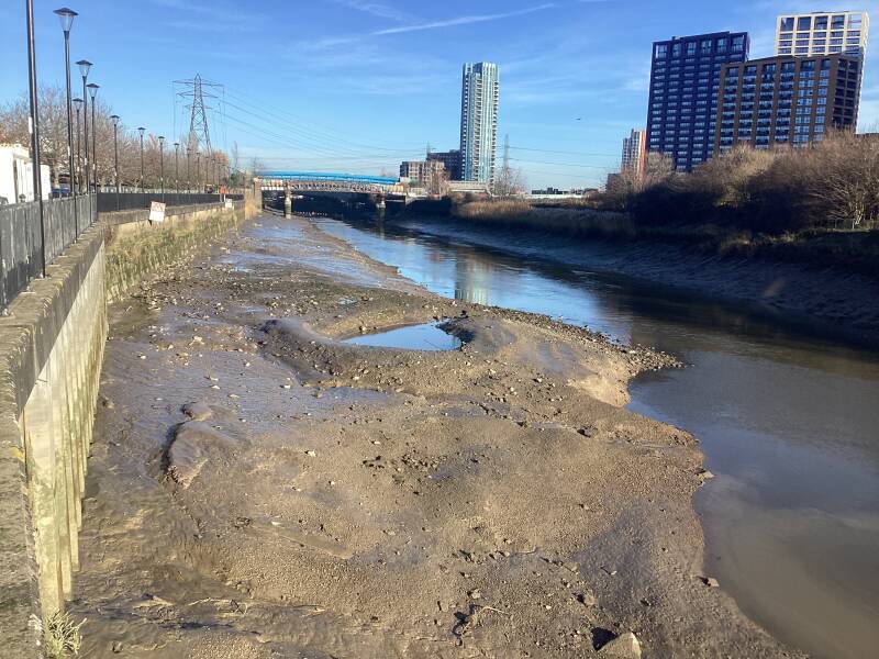
RIVER LEA
Site of the COPPERAS
Situated on the west bank of the River Lea, just within the parish of St Leonard's Bromley, this was one of the earliest industrial sites in the Blackwall area having no connection with shipbuilding.
A copperas works was established here in the seventeenth century, and continued in business until the East India Dock Company bought the premises early in the nineteenth century. Leamouth Road bisects the site, which was partly absorbed into the curtilage of the East India Docks. The remainder of the site, between the road and the river (where the copperas house itself stood), became Orchard Wharf, latterly the premises of J. J. Prior (Transport) Ltd.
The manufacture of green copperas (ferrous sulphate), a chemical used in dyeing cloth, tanning and the making of black ink, was an important industry around the Essex coast during the eighteenth century. Its centre was at Walton-on-the-Naze, where copperas was being made by 1690. Little is known about the origins of the Lea-side works. In the 1690s they belonged to Sir Nicholas Crispe, the 2nd baronet (c1643–98), who held the site on lease from the then freeholder, Sir Thomas Middleton. Crispe was also the joint-owner of another copperas works at Deptford, and it seems likely that he established the Blackwall works. There is, however, a possibility that the founder was his grandfather, Sir Nicholas Crispe, the 1st baronet (d. 1666), who was certainly interested in copperas, having been farmer of the customs and subsidies of both copperas and alum.

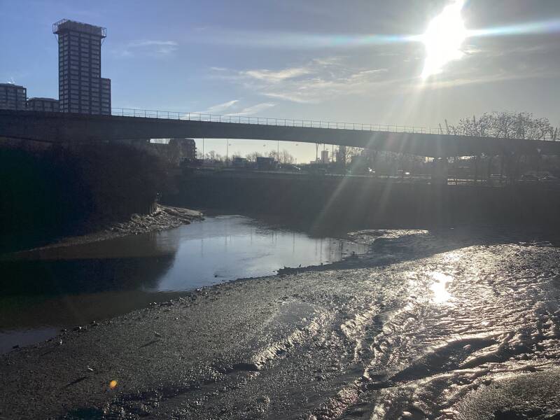
You leave the Lower Lea Crossing to your left, and you continue with the former East India Dock basin to your right
Orchard Place (street)
SALOME GATES
EAST OF BKACKWALL…
The area of eastern Blackwall formerly known as Orchard House was for over 150 years one of the most isolated and least accessible parts of Poplar. It lies at the eastern extremity of the parish where the confluence of the Thames and the meandering River Lea (here called Bow Creek) produces two peninsulas with a thumb-andforefinger-like configuration. The construction of the East India Docks in 1803–6 cut this area off from the rest of Poplar, and made it difficult of access by road. While not inhibiting the industrial development of the district, this encouraged the growth of a poor but self-contained community of whose existence the outside world seemed largely oblivious. 'London's "Lost" Village', as it was called in 1931, had no public transport links with the rest of Poplar, and any would-be visitors were faced with a long walk down the 'forbidding-looking thoroughfare bearing the picturesque name of Leamouth Road, flanked on both sides by the high stark walls of the adjacent dock premises' (Plate 111). (fn. 2) The community here was destroyed in the 1930s, when most of the houses were pulled down under slum clearance orders and their inhabitants moved elsewhere. Local industries, on the other hand, did not move out
Two modern developments: to the left London City Island, historically called GOODLUCK HOPE, to the right ORCHARD PLACE or LEAMOUTH PENINSULA

To your right: ORCHARD PLACE or LEAMOUTH PENINSULA
The Orchard House property, or Pemell Estate as it was known in the nineteenth century, was the larger of the two main land holdings, with some 20 acres. (fn. 3) It comprised the whole of the east-pointing peninsula formed by the confluence of the Lea and the Thames, and extended westwards to include areas later swallowed up by successive enlargements of the East India Dock basin.
Also known from its location as Leamouth (or 'Laymouth'), the estate took its name from the Orchard House, a moated property comprising a house and a large orchard, which formerly occupied much of the eastern peninsula.
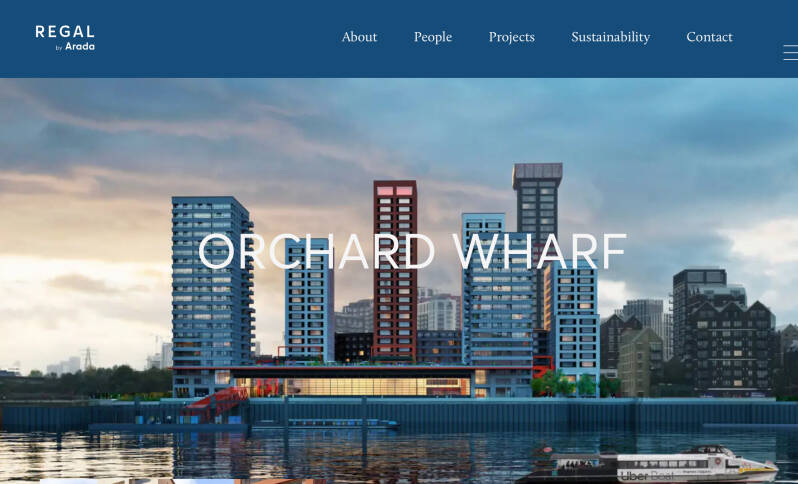
ORCHARD WHARF. Future developments…
A Safegarded (working) wharf?
The developers agreed outline lease terms with Thames Clippers Logistics to build a sustainable logistics solution at Orchard Wharf for the future needs of London. The proposed warehouse and reactivated wharf will be operated by Thames Clippers Logistics as part of their wider strategy to develop a high speed light river freight logistics service transporting cargo on behalf of businesses.
Goods are delivered by electric vehicle to the Port of London Authority’s Dartford facility and loaded onto the HVO biofuel powered Thames Clippers Logistics’ vessel, then transported at high speed to Trinity Buoy Wharf and Bankside piers. Last mile delivery is then provided by electric vehicle (Speedy Services) and electrically-assisted cargo bike (Lyreco).
Modern residential developments, called now GOODLUCK HOPE
Former ORCHARD DRY DOCK (GRAVING DOCK)
The dry dock at Orchard Dock was acquired by the newly formed London Graving Dock Company in 1890. The company used it for ship repair, notably cutting the liner Eastern Coast in half for repair after a collision in 1948.
- By the late 1960s, the ship repair industry was in decline. Shell Tankers Ltd purchased the site and the dock was filled in during the early 1970s.
- The London Docklands Development Corporation (LDDC) acquired the general area in the 1980s. The site, including the dock, was later part of the large-scale redevelopment of the Leamouth Peninsula.
The dock has been restored as part of the area's landscaping, with an existing caisson (floating gate) restored and reused as a viewing platform that overlooks the River Thames and the O2 Arena.
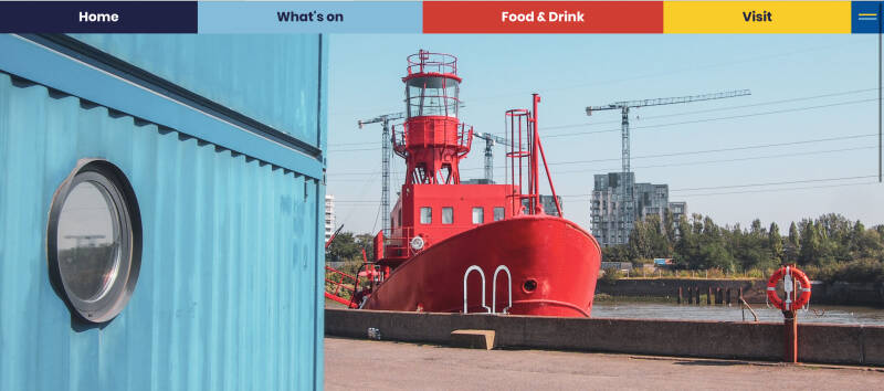
TRINITY BUOY WHARF

Trinity Buoy Wharf is a creative site in Docklands developed and managed by Urban Space Management Ltd. Home to London’s only Lighthouse, a vibrant creative community, a sculpture park, event venues and Container City™ Buildings.
Since Urban Space Management took over this vacant site in 1998, Trinity Buoy Wharf has seen a stream of artists, photographers, designer- makers, web designers and small businesses settle in its low-cost workspaces and studios. Home to a thriving creative community of over 750 people, Trinity Buoy Wharf is a base for English National Opera, Uber Boat by Thames Clippers, Faraday School, The Big Draw and The King’s Foundation to name a few.
THE CORPORATION OF TRINITY HOUSE of DEPTFORD STROND
Trinity House, founded by Royal Charter in 1514, was established originally at DEPTFORD is the General lighthouse authority for England, Wales, the Channel Islands, and Gibraltar. It maintains navigational aids such as light vessels and buoys, as well as communications services and pilotage for ships in the North Sea. These are financed by dues levied on commercial vessels calling at ports in the British Isles.
In addition, Trinity operates a registered charity, which provides welfare services for retired seamen, education, and promoting safety at sea. Funding for this is generated separately.
Trinity House had its headquarters in a fine building in the City designed by the great James Wyatt in 1798,
TH established Trinity Buoy Wharf as its Thames-side workshop in 1803. At first wooden buoys and sea marks were made and stored here, and a mooring was provided for the Trinity House yacht, which was used to lay the buoys and collect them for maintenance and repair. The river wall along the Lea was rebuilt in brick in 1822, making this the oldest surviving structure on the site.
Many new buildings were constructed during the Victorian period, and a number still survive of which the earliest, the Electrician's Building, was built in 1836. It was designed by the then Chief Engineer of Trinity House, James Walker, originally for the storage of oil. He rebuilt the remainder of the river wall in 1852, and the first of two lighthouses here in 1854. On his death in 1862 he was succeeded by James Douglass who designed the lighthouse that still stands today as London's only remaining Lighthouse.
The iconic Experimental Lighthouse, and its neighbour the Chain and Buoy Store were built by Douglass in 1864 and were in constant use to test maritime lighting equipment and train lighthouse keepers. The roof space adjoining the present lighthouse housed the workshop for the famous scientist Michael Faraday.
In 1869, Trinity House set up an engineering establishment at Trinity Buoy Wharf to repair and test the new iron buoys then coming into use. Overcrowding soon became a problem, and in 1875 the works expanded westwards into the neighbouring property, previously Green's Shipyard. By 1910 Trinity Buoy Wharf was a major local employer, with some 150 engineers, platers, riveters, pattern makers, blacksmith, tinsmiths, carpenters, painters, chain testers and labourers working here.
The Wharf continued through the twentieth century to be responsible for supplying and maintaining navigation buoys and lightships between Southwold in Suffolk and Dungeness in Kent. It was modernised and partially rebuilt between 1947 and 1966, and finally closed on 3rd December 1988 when it was purchased by the London Docklands Development Corporation. In 1998 Urban Space Management took the site on a long lease.
Who makes buoys now?
Buoys and sea marks in England are managed and sourced by various entities, primarily the Corporation of Trinity House.
Trinity House is responsible for all navigation aids around England, Wales, and the Channel Islands, while other local port and harbour authorities manage their own areas. There is no single "factory" where all buoys are made; rather, they are sourced from commercial manufacturers and maintained at various depots.
Trinity House: As the General Lighthouse Authority for England and Wales, it maintains approximately 450 buoys and inspects many others. Historically, their primary workshop was Trinity Buoy Wharf in London, which closed in 1988. Today, Trinity House operates from various bases, including its Harwich headquarters, to deploy and service buoys using vessels like the THV Galatea.
Individual port and harbour authorities, as well as operators of wind farms and utility companies, are responsible for deploying and maintaining buoys in their specific jurisdictions.
Scotland and Isle of Man: In these areas, buoys are managed by the Northern Lighthouse Board.
The actual buoys and components (such as lights, fog signals, and top marks) are manufactured by a range of specialist commercial companies. These companies produce durable buoys made of materials like steel, plastic, or fiberglass designed to withstand harsh marine conditions.
Examples of how buoys are sourced and supplied include:
Companies like JFC Marine fabricate top marks and navigation posts and manufacture mooring buoys.
Hydrosphere, a marine equipment supplier, has provided racing marker buoys to sailing clubs on the Isle of Wight.
What to visit, where to eat?
The Lighthouse & Longplayer: Visit London's only lighthouse, where you can hear Longplayer, a piece of music designed to play for 1,000 years.
The Faraday Effect: An immersive installation in a tiny hut, recreating Michael Faraday's workshop and experiments.
Sculpture Trail: Discover whimsical sculptures by artist Andrew Baldwin dotted around the site.
Container City: Explore innovative buildings made from repurposed shipping containers, housing artists and businesses.
Story Box: Watch videos about the site's history and film appearances.
Time and Tide Bell: A bell that chimes with the rhythm of the Thames, part of a national series.
Historic Boats: See original Thames lighters and other vessels.
Fat Boy's Diner: An authentic 1940s American diner for classic food and a nostalgic atmosphere.
Orchard Cafe: A casual spot located in a shipping container.
LIGHTSHIP LV95
Built in 1939 by Philip and Sons of Dartmouth for Trinity House and used mainly at their South Goodwin station on the Goodwin Sands and at other stations including Inner Dowsing off the coast of Norfolk. It is 1 of 3 built to the same design; 93 in Victoria Dock and 94 in Rotterdam. It was the first UK Light Vessel to be converted to solar power in the 1990's to allow for automatic unmanned operation and was in service until 2003 following a complete refit in 1999 in which all original machinery and crew accommodation were removed.
Sold at auction by Trinity House to the owner of Port Werburgh marina on the Medway it was later sold on to Ben Phillips who converted it to a floating music recording studio and based it at Trinity Buoy Wharf from 2008.
SS ROBIN
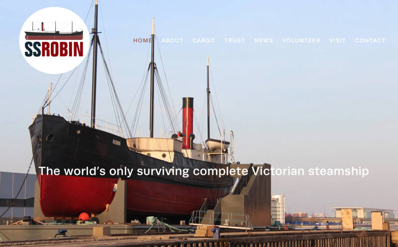
A 350 gross registered ton(GRT) steam coaster, a class of steamshipdesigned for carrying bulk and general cargoes in coastal waters, and the oldest complete example in the world. One of a pair of coasters built in Bow Creek, London in 1890, the ship was built for British owners, but spent most of her long working life on the Spanish coast as Maria.
In 1974, she was purchased for restoration as Robin and is listed by National Historic Shipsas part of the National Historic Fleet

Now, you have to retrace the route in order to visit London City Island, on your way to CANNING TOWN
LONDON CITY ISLAND. Historically GOODLUCK HOPE
EATERIES
CITY ISLAND BRIDGE
This 80-metre red bridge is set on the Lea River’s meander, known as Bow Creek, and directly connects the island with nearby Canning Town and Canary Wharf. Purposefully designed by Davies, Maguire and Whitby to accommodate the residents of City Island
Rotunda: entrance to CANNING TOWN STATION: L.U., DLR and bus and Canning Town town centre
Lea River Riverside Path to the LIMMO PENINSULA new development?
The Limmo Peninsula, a five-hectare brownfield site in East London, is set to be transformed into a thriving new neighbourhood. This ambitious residential-led development aims to deliver approximately 1,400 new homes, playing a crucial role in addressing London's urgent housing needs. Formerly a vital staging ground for the construction of the Elizabeth line, where tunnelling machines were lowered, the site is now poised for a new chapter of urban regeneration.
Lea River riverside path to BOW CREEK NATURAL RESERVE (Lea Valley Regional Park)
Welcome to Canning Town!


Alternative Route to Canning Town
Route to POPLAR DOCK (WEST INDIA DOCKS) and Blackwall Riverside: VIRGINIA QUAY and EAST INDIA DOCK BASIN
BLACKWALL DLR Sta.
Poplar High St. (Eastern end)
BLACKWALL TUNNEL NORTH ENTRANCE
Cycle/Walking Subway under Aspen Way. You emerge in Preston Road by the Poplar Marina
Trafalgar Way
Student Accommodation
NEW BILLINGSGATE, Wholesale Fish Market, is only a stone throw
And a piece of artwork…
Former POPLAR DOCK, now MARINA
A small dock in Poplar, London. It connects to the Blackwall Basin of the West India Docks and, although independent of this system, has never had a direct connection to the Thames.
Originally a series of reservoirs built by the West India Dock Company and completed in 1828, Poplar Dock was converted into a railway dock, in the days before any of London's enclosed dock systems were connected to the railway network. The dock was built by the East & West India Docks and Birmingham Junction Railway Company (later the North London Railway Company) and connected to the company's goods yard at Chalk Farm.
Because of its lack of a direct connection to the river, its operators needed the agreement of the owners of the West India Docks for uses which did not compete directly with their interests. In its early years the dock was used mainly to import coal from the Northeast of England.
Much of the dock survives today as a mooring connected to Blackwall Basin. Poplar Dock is now known as Poplar Dock Marina. It was opened by Queen Elizabeth II in 1999.
Cross Preston Road
BLACKWALL
This is , in act, an area of Poplar The neighbourhood includes Leamouth and the Coldharbour conservation area.
The area takes its name from a historic stretch of riverside wall built along an outside curve of the Thames, to protect the area from flooding.
Blackwall was once a significant ocean-going port and so was a natural location in which for Raleigh to base himself in London. In the early seventeenth century Blackwall was the main departure point for the English colonization of North America and the West Indies.
In 1576, Martin Frobisher left Blackwall and landed at Frobisher Bay on Baffin Island, claiming it for England (its first overseas possession) in the name of Queen Elizabeth I. Frobisher was funded by the Muscovy Company seeking the North West Passage.[10][11] In the early years of the 17th century the port was the main departure point of the English colonisation of North America and the West Indieslaunched by the London Company. On 20 December 1606, three ships, Susan Constant, Godspeed and Discovery, sailed from Blackwall, landing in Virginia on 26 April 1607 to establish the first permanent English settlement, Jamestown
Raleana St.
Did a very important figure in the early period of seafaring and colonisation lived here: WALTER RALEIGH?
While Sir Walter Raleigh was often in Blackwall for naval business and lived in a house there on many occasions, he did not personally sail for North America from Blackwall or anywhere else; he never actually visited the American colony he sponsored. His expeditions were organized and financed by him, but led by others.
- Raleigh was a prominent courtier and Queen Elizabeth I wished to keep him close, forbidding him from leading the voyages himself.
- He organized the expeditions to Roanoke Island (in modern-day North Carolina) in the 1580s, which were led by captains Philip Amadas and Arthur Barlowe in 1584, and later by John White in 1587.
- Raleigh did lead two expeditions to the Orinoco river basin in South America in search of the fabled city of El Dorado, in 1595 and 1617, after his initial North American ventures.
Roanoke Island
the "
Lost Colony," refers to the disappearance of over 100 English settlers from Roanoke Island (now North Carolina) in the late 1580s, with the last clue being the word "Croatoan" carved on a post when Governor John White returned in 1590, baffling historians for centuries, though recent evidence suggests the colonists may have integrated and split into smaller groups with local tribes, eventually disappearing into the Indigenous population rather than being wiped out.
-
- 1587: John White leads 117 men, women, and children to establish a permanent English settlement on Roanoke Island, part of Sir Walter Raleigh's colonization efforts.
- 1588: White returns to England for supplies but is delayed by the Anglo-Spanish War (Armada).
- 1590: White finally returns to find the settlement deserted, houses dismantled, and no colonists present.
- The Clue: The only clues were "CROATOAN" carved into a palisade and "CRO" on a tree, indicating a possible move to nearby Croatoan (now Hatteras) Island or assimilation with the Croatoan people.
Major Theories- Assimilation: The most accepted theory now suggests they integrated with local Algonquian tribes, potentially splitting into smaller groups and losing their English identity over time, as indicated by archaeological finds of combined English and Native artifacts.
- Attack/Massacre: Some theories propose violent conflict with hostile tribes or Spanish forces.
- Starvation/Disease: The colonists may have succumbed to famine or illness.
- Attempted Return: They might have tried to sail back to England and were lost at sea.
- Archaeological digs, particularly by the First Colony Foundation, have uncovered evidence of English blacksmithing (hammer scale) and domestic pottery near known Native American settlements, suggesting interaction and shared living spaces.
- Artifacts like a copper earring (suggesting trade with English goods) found near Algonquian pottery further support the idea of integration rather than disappearance or massacre.
Baffin Way
New Providence Wharf
Designed by Skidmore, Owings and Merrilland is managed by Ballymore, a property development company.
It consists of a crescent-shaped block along Fairmont Avenue and Yabsley Street (New Providence Block A-E, with 559 apartments), two taller buildings - the Ontario Tower (256 apartments) and Charrington Tower (originally Providence Tower, 360 apartments) - the Michigan Building (72 apartments) and Columbia West (19 apartments)
A few features that deserve attention, although they are out of public eye or acces:
Blackwall Tunnel ventilation shafts
Waste Transfer Station
Blackwall Stairs
historic riverside landing in East London, a famous departure point for voyages like the first colonists to Virginia, situated near the former major shipbuilding area of Blackwall Yard, and is a navigational reference point on the Thames for vessels
Blackwall Way
Pumping Station, now Majestic Wines shop
The old pump house at Blackwall Way, part of the London Hydraulic Power Company network, was built to pump high-pressure water through underground pipes to power city services like lifts, cranes, and theatre machinery, offering a cleaner alternative to steam. It drew water from the Thames and supplied power for various industrial and commercial needs across London until it was eventually superseded by electricity. Hydraulic The building was a crucial part of a vast network of pipes
The pressurised water (around 700 psi) was used to operate heavy machinery, including: Lifts & Cranes for docks, warehouses, and buildings; revolving stages and safety curtains in West End theatres; providing a high-pressure water source for hydrants.
It provided a centralized, cleaner power source than individual steam engines, reducing smoke and fire risk in busy areas.
This specific pump house was constructed in 1902 as one of several strategically placed stations. The network eventually became obsolete with the rise of electric power, leading to the closure of these stations.
All this area is the site of the former BLACKWALL YARD: shipbuilding took place here for centuries
Blackwall was a shipbuilding area since the Middle Ages. In 1607, the Honorable East India Company (HEIC) decided to build its own ships and leased a yard in Deptford. Initially, this change of policy proved profitable as the first ships cost the Company about £10 per ton instead of the £45 per ton that it had been paying to have ships built for it.
However, the situation changed as the Deptford yard came to be expensive to run. By 1614 the East India Company outgrew Deptford and ordered William Burrell to begin work on a new yard for repair, construction and loading of out-going ships. The site Burrell selected was at Blackwall, which was further down river and had deeper water, allowing laden ships to moor closer to the dock. The new yard was fully operational by 1617. The yard and its facilities were enlarged repeatedly during the early 17th Century. The yard was surrounded by a 12-foot (3.7 m) high wall, but was not used for storage of imported goods.
Later on in the 17th century the East India Company reverted to its original practice of hiring vessels. In 1656, following a decline in the East India Company's fortunes, the yard was sold to shipwright Henry Johnson. The Anglo-Dutch wars of the late 17th Century resulted in too much work for the royal dockyards, and the Navy Board under Samuel Pepys began to commission third rates from Blackwall which was by then the largest private yard
However, it. was overtaken in importance by Bronsdens yard at Deptford. With the end of the Dutch wars naval shipbuilding had also retreated to the royal yards. This was reversed by war with Spain in 1739
The yard recovered under the management and later ownership of the Perry family. When the Navy again surveyed the yard in 1742, the yard had the greatest capacity on the Thames. In 1784 when Francis Holman painted it, it was said to be the biggest private yard in the world. It was at this time that the Perrys began construction of the large Brunswick Dock to the east of the yard, opened in 1790.
The yard was reduced in size in 1803 when the East India Dock company bought the eastern part including the Brunswick Dock. The Brunswick Dock became the East India Export Dock (the southern of two docks), which in the 20th Century was filled to become the site of Brunswick Wharf Power Station
became Perry Sons & Green (George Green having married into the family)), then Perry Wells & Green (a half share having been sold to Rotherhithe shipbuilder John Wells) and eventually Wigram & Green.
In 1821 the firm built its first steamship. During this period the yard built Blackwall Frigates.
In 1834 the paddle-steamer Nile was built for delivery to the Egyptian Navy.
In 1843 the remaining site was split into two yards, with Money Wigram & Sons in the western yard. Wigrams soon began construction of iron ships, but ceased building in 1876.[6] In 1877 Wigram's yard was bought by the Midland Railway and developed as a coal dock, which survived until the 1950s.
seriously damaged by bombing and it was later filled in and used as a fuel oil storage yard by Charringtons. Part of the site is now occupied by the northern ventilation shaft of the second Blackwall Tunneland the rest by housing.
PLANS OF THE DOCKYARDS (MARITIME MUSEUM):https://www.rmg.co.uk/collections/objects/rmgc-object-496267
Future developments
This is one of Tower Hamlets’ last underdeveloped riverfront sites. Sat within a locale rich in maritime history, this new neighbourhood will build a thriving and sustainable community.
Located on a 1.7-hectare site, “Blackwall Yard” will provide almost 900 homes, including 35% affordable, with a vast range of shared amenities and facilities, making it a sustainable ‘compact city’.
Working collaboratively with White Architekter, Panter Hudspith, and landscape architects LDA, the neighbourhood is formed of four buildings carefully arranged around a listed graving dock, from which the public realm will act as a stage for community life, including a primary school, a cafe square, abundant play space and a riverside pub.
Former THOMSON-REUTERS data centre, now TELEHOUSE South
A significant modern building designed by Rogers Stirk Harbour + Partners, which housed crucial tech infrastructure and later became part of a large redevelopment site (Blackwall Yard) for residential use, sold by Reuters to developers around 2020

SUPER-LOOP
EAST INDIA DLR Station
Convenience store

John Smith Mews, Newport Avenue, Jamestown Way… those street names give you a clue
Newport Avenue
Prime Meridian Court. Site ofthe BRUNSWICK HOTEL
In 1840 a 3½ mile railway line was opened to connect the City with the West India and East India Docks. The railway company purchased the East India Company’s Brunswick Wharf as the riverside terminus, which they renamed Brunswick Pier. As the docks were quite a distance from London the dock company created the Brunswick Hotel, built exactly on the meridian line. In the 1830s the hotel became famous for its whitebait dinners, for which politicians, aristocrats and fashionable men, including King William IV would travel from London by boat. During the 19th century emigrants waiting to embark to Australia and New Zealand would stay at the hotel. The Brunswick Hotel survived until it was demolished in 1930.
Riverside path
Site of the EXPORT DOCK


Site of the railway station (where Jamestown Way now is)
The historic Blackwall railway station, the eastern terminus of the COMMERCIAL RAILWAY, later the London and Blackwall Railway (LBR(, opened in 1840 and was demolished in 1946 to make way for a power station. No trace of the original station remains today, with the site now covered by modern development and Jamestown Way.
This terminus was unique for using an unusual system of rope-haulage by stationary steam engines, due to fire risks in the dock areas, rather than conventional locomotives. The station was an ornate, two-storey building designed by the architect William Tite.
It served a varied clientele, including dock workers and emigrants who would take a ferry service from the adjacent pier to large sea-going liners at Gravesend, Kent.
Passenger services were suspended early on May 3, 1926, during the national General Strike, and never resumed. Goods traffic on the branch line continued until the late 1960s
Site of the BRUNSWICK WHARF (or BLACKWALL) POWER STATION

Three blocks called Elektron Towers and a block called Switch House have been built around the site of the power station. The current site also contains the Brunswick Wharf Substation
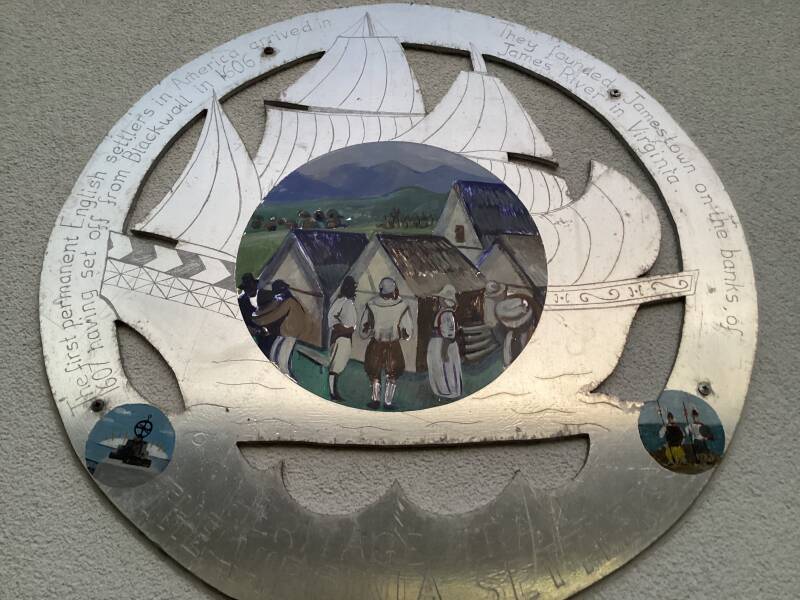
VIRGINIA QUAY SETTLERS MONUMENT
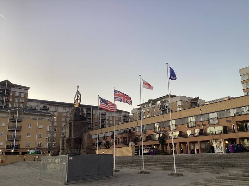

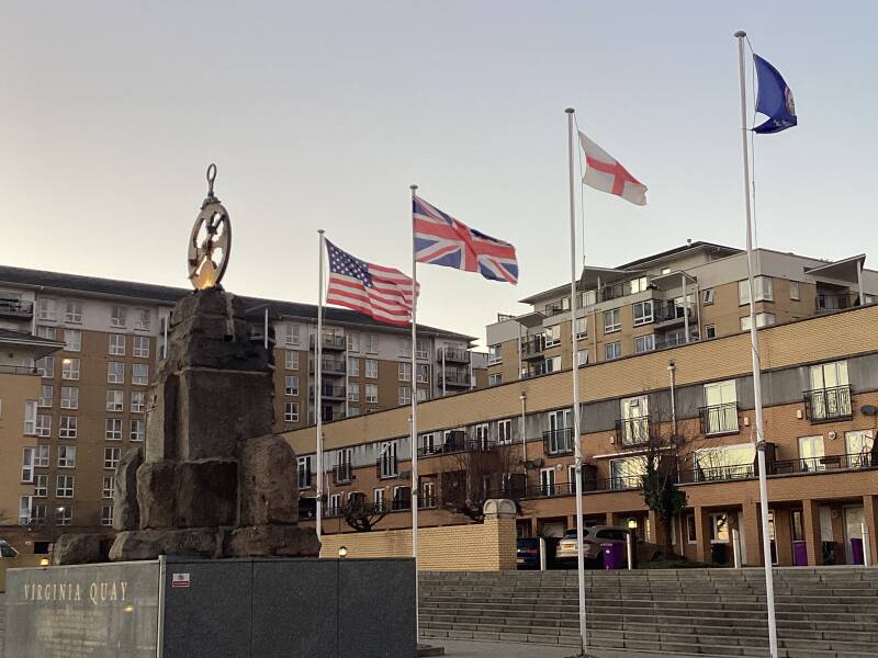
The Virginia Quay Settlers Monument, a free-standing stone and bronze monument of 1951, incorporating a bronze plaque of 1928 and with later sculptural additions of 1999, commemorating the departure of settlers for Jamestown, Virginia (USA), is listed at Grade II for its historic interest as the monument is an accessible memorial to the British settlers who set out from Blackwall Quay to establish a colony at Jamestown, Virginia (USA) in 1607
And as well for its artistic and sculptural interest: the monument's rough-hewn rock base and astrolabe navigation instrument combine to convey the sense of adventure involved in crossing the Atlantic during the C17, and the risks associated with establishing a colony on an unknown continent;
Wendy Taylor’s astrolabe is a well-detailed addition to the memorial reflective of her oeuvre;
* Historic association: with the Pocahontas Statue at Gravesend
Captain Newport, John Smith (mutineer, but a future councillor and leader), John Rolfe(merchant) and his future wife Rebecca (first known as… Princess Pocahontas!)
The flotilla was made up of three small ships - Susan Constant, the Godspeed and the Discovery. During the voyage there were times when the ships lay becalmed and it was on one of these occasions that Captain John Smith, a soldier and adventurer, was charged with mutiny by Captain Christopher Newport who was in overall charge of the passage. Smith was then held securely for the rest of the voyage, pending execution on landfall.
On reaching America in April 1607 the expedition leader opened a sealed box containing orders. John Smith was listed as a named councillor for the new colony, and as such he was pardoned. Many of the settlers were exhausted and sick from the long and arduous trip, but they established Jamestown as the first Virginia English colony. It is situated on the banks of the Back River, 60 miles from the mouth of the Chesapeake Bay.
Almost immediately they were attacked by Native Americans, necessitating the rapid construction of a secure timber stockade. Disease, famine and continuing attacks took their toll on the population and by 1609 only 60 of the original c105 settlers survived. Captain John Rolfe joined the colony in 1610, bringing with him tobacco seeds which thrived in the local climate and Virginia was eventually established as a tobacco-based colony.
Legend has it that Captain Smith was captured by Native Americans and that his life was saved by Pocahontas, the daughter of a Chief. She later converted to Christianity and after marrying John Rolfe, as Rebecca Rolfe she visited England, where she helped recruit more settlers and raise funds. On her return journey in 1617 she fell ill at Gravesend, and died a few days later. She was buried under the chancel of the Church of St George, and a statue of her stands in the graveyard
The first colonists of Virginia sailed from the Blackwall Steps.
Former Lock
The wide entrance lock of the East India Docks, which had been enlarged to 65-feet wide in the 1870s, made them accessible to larger ships than at the West India Docks.
EAST INDIA DOCK BASIN NATURAL PARK
The only surviving basin of the East India Docks is the Entrance Basin, which eventually became a nature reserve as part of the Lee Valley Park with several Grade II listed features. East India Dock Basin is the largest remaining part of the early 19th century East India Docks complex. Owned by Lee Valley Regional Park Authority it has been identified as a site to be enhanced to fulfil its potential as a heritage resource and nature reserve.
COMPLETE HISTORY OF THE E.I.D: https://www.thehistoryoflondon.co.uk/the-east-india-docks
MILLENIUM BEACON
QUEEN ELIZABETH II had lit the National Millennium Beacon, triggering a string of 10,000 beacons across the UK.
THE NEW MILLENIUM (1999). http://news.bbc.co.uk/1/hi/uk/586490.stm
SALOME GATES
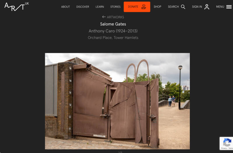

Exiting the Gates you are in Orchard Place, Leamouth, for
TRINITY BUOY WHARF and LONDON CITY ISLAND, and for ROYAL DOCKS (Lower Lea Crossing viaduct) and CANNING TOWN (through London City Island or along Bow Creek -River Lea- and Barking Rd.)
Bus routes SUPER-LOOP and D3